• Home
  • Map & Hours
  • Store
  • Donate
  • Records
  • More Info
      • Custer State Park
      • The Objective
      • CSP Architecture
      • Camp Lodge
      • CSP Area Map
      • Digital Library
      • All Images
      • Mayo, Camp & Men
      • Orman Dining Hall
      • Tent Camp Savoy
      • The CCC
      • The Beginning
      • What & Who
      • Reunion Dedication
      • New Recruit Handbook
  • CCC Men
    • The Workers
    • Seventh Corps
  • About
    • About
    • Volunteer
    • Official CCC Museum
  • Contact
South Dakota CCC
Share it! Facebook Twitter LinkedIn Pinterest
Site Search
Posts | Enrollees
| Museum Collection
| CCC Camps
| Camps Map
| Museum Store

Designation: F-6  Date: 2015-07-17

Roubaix

South Dakota Civilian Conservation Corps (CCC) camp 16 mi SE of Deadwood

F-6-Roubaix

1933, 06/03 - 1935, Spr, 792
1935, Spr-Fall, 2759V
1935, Fall, 792
Date Closed: 1941, 09/15

Camp F-6 (Roubaix) was located 15 miles south of Deadwood, on the west side of U.S. Highway 385 (1934).

It straddled a ravine in the NE 1/4 of SW 1/4 of section 20, T 3N, R 4E that drained into Middle Box Elder Creek from the north. At this writing (1986) the chimney for the officers' quarters is visible from the highway several hundred yards north of the road to Lake Roubaix.

The original buildings included the mess hall, hospital, bath house, recreation hall, administration building, supply building, forestry and army garages, laundry, and pump (1934). In 1934 a new hospital and officers' quarters were built; the hospital was remodeled for use as an administration building; and part of the administration building was transformed into a barracks (1935).

The camp was established June 3, and closed September 15, 1941.x

xDerschied, Lyle A. "The Civilian Conservation Corps in South Dakota, 1933-1942." Brookings, SD, South Dakota State University Foundation Press, 1986. No longer in print. Available at some libraries but may not be checked-out.

Roubaix DamThe Dam at Roubaix
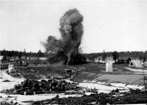
photo courtesy Charles Kewley
Roubaix Historical Marker

Historical Marker on Hwy 385

Lat / Lon always verify yourself
44.199795-103.660782
GPS always verify yourself
44° 11' 59.262" N103° 39' 38.815" W

Large Map

The CCC Men
Enrollee Records
The CCC Camps
Life in a CCC Camp
What and Who
Tourism, Recreation and CCC
Digital Library
Art Returns Home
Camps
Horse Creek
Deerfield
Calcite
Lodge
Park Creek
Men
Chris Vigre
Harold Harrison
Ernest Bennett
John Marso
Chester Clute
Interesting Posts
Jan Conn Visits CCC Museum
Hendrickson Receives Legacy Pin
See See See
The CCC and The Internet
CCC Man Identified
Museum Store
Wooden Container
Wooden Boot Jack
Badlands National Park
Custer County
Wind Cave National Park: The First 100 Years
Home | Contact
"a museum in which the historical significance and accomplishments of the Civilian Conservation Corps are recognized and perpetuated"
CCC on FacebookCCC on TwitterCCC on YouTubeCCC on GoogleCCC on InstagramCCC on Linkedin
Civilian Conservation Corps (CCC) Museum of South Dakota is a 501(c)3 nonprofit organization.
All information deemed reliable but not guaranteed and should be independently verified. www.SouthDakotaCCC.org - Copyright © June 2025 CCC Museum of South Dakota. All rights reserved. Revised: June 2025. You may not copy, reproduce, or use any data, images, or other materials from this site for any purpose without expressed written consent. All Text and Photos are Copyright Protected by International Law. All Logos and Trademarks mentioned herein belong to their respective owners.
↑